Imagine you are walking in a field being given instructions over a radio. You are told to turn 40° and walk forwards.
How do you know you are going the correct way? Did you turn 40° clockwise or anticlockwise?
While this scenario might sound false, this situation comes up a lot in navigation.
How do we solve this problem?
To solve this, we use bearings.
Bearings are a way of defining an angle in a precise way that avoids confusion.
The three rules of bearings:
1) Bearings are always measured from north - that is directly up on a map.
2) Bearings are always measured clockwise.
3) Bearings are always written with 3 figures i.e. 40° would be written as 040°
Example:
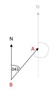
Point A is on a bearing of 043° from point B. What is the bearing of B from A?
This is best if you sketch it out first:
It's important to put A and B in the correct place. The question states that the bearing is from B - this means that the bearing starts from B.
Next, we identify the return bearing:
We are asked for the bearing of B from A. We need to draw a line straight up (north) and then go clockwise from it until we get back to the line.
Finally, work out the angle:
A line straight down must give the angle 180°
Because the two lines going up are both north, this means they are parallel, so we can say that the rest of the angle is 043°
This gives the return bearing (B from A) as 180 + 43 = 223°
It may seem complicated but follow those three rules and it should make things a lot easier. Let's move on to some questions now.


